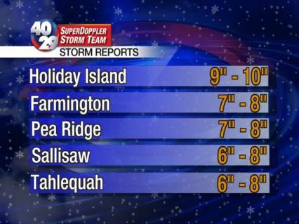
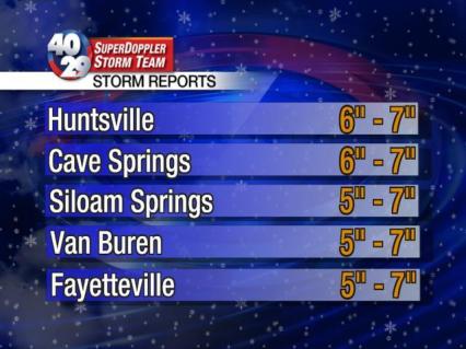
I want to thank everyone who provided us with snow totals through this event. It really helps us out, not only with providing the information on-air and online but it helps us with nowcasting during the storm. We have received dozens and dozens of totals. I wish we had the time to mention everyone during our weathercasts but that isn’t possible. Instead we compiled 3 graphics with 15 totals. You will notice the totals are in a range, this is because we have had many varying totals in and around each city which is common during a storm like this.
As for ice totals, most of Benton County reported ice totals of around 0.25″. Ice totals ranged from 0.25-0.50″ in Washington County with a few locally higher amounts. Most of the river valley picked up less than 0.10″. The Ouachitas picked up on average 0.25″ but this varied widely with the topography.
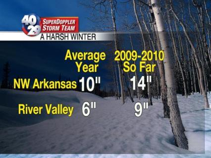
Winter so far has brought 3 significant winter storms. The snow totals on average in northwest Arkansas now sits around 14″ for the year, which is already 4″ above average for the entire winter season. We are 3″ above normal for the River Valley. Since there have been so many below normal years for snowfall in the past decade, the winter of 2009-10 now ranks as the harshest winter since the year 1999-00 as a whole across the viewing area. All of this and we are only 41 days into winter…we have 48 more days until the first day of spring.
Ross Ellet
Follow us on twitter “4029weather”


Most of Polk County had an inch and a half or so lquid precip., so I guess we’re lucky we missed most of the frozen stuff!!Though the snow we did get was nice to see..
8 inches final total after the storm in hodgen ok
I agree with jerry kelly. Here in Clarksville it was mainly sleet. Had it been freezing rain before it changed to snow, who knows how bad it might’ve been. We ended up with about 5 inches of snow here. Most I’ve seen in about 10 years with 1 event!!!
Three? I thought this was just the second. There was the one during Christmas and I know there was an event during New Years, however was that a separate system? I thought it was the same system?
Jack,
It was two separate systems with in an active pattern.
Ross Ellet
When do you expect the freezing fog to clear out? I think we have more ice in the trees this morning than we did yesterday. (Rogers)
Sarah,
We will have another round tonight with the fog clearing around 10am tomorrow.
Ross Ellet
According to the persimmon seed we have 4-6 more snows to go!!!
Exended forcasts showing old man winter got anything left???… or does your gut think we are done with any more snow/ice accumulations in NWA.
Thanks
JD,
Given the weather pattern that we are in, my gut is that will see more winter weather this year. The long range maps (8 to 14 days away) are showing an active pattern with lots of cold air. Also, another refreeze will occur overnight tonight.
Ross Ellet
Also,
I live a mile off a rain main road (that has been cleared off), but getting there is slightly treacherous.
With the temperatures barely climbing over 32 today… I foresee school closings again for NWA public schools as bus routes are not ready.
A refreeze of the slush again tonight?
What are the long range forecasts looking like over the next 10 days or so? Any more winter weather?
Drake,
It doesn’t look like there will be any winter weather over the next 7 days but after that point the 8 to 14 day outlook shows an active pattern with cold conditions. We will wait and see.
Ross Ellet
Ross, you are the man! Just so you know!
Great addition to 4029TV. Don’t remember exactly when you joined on.
Hope you are liking the area and stay a very long time!